MAPPING THE CLAN MUNRO
This is the essential guide to Ferindonald and the Munro clanlands in Ross-shire, and will have strong appeal for anyone with an interest in Munro country and those who are planning a visit. Mapping the Clan Munro lists on one side of a folding sheet all the old Munro properties, churches, battle sites and other places of interest, and shows them clearly on a map of the area. Overleaf is the illustrated text by the Clan's much respected late Hon. Historian, R.W.Munro which gives brief insights into how these properties were lost and won by the Clan, and details the significance of each.
Mapping the Clan Munro is published by the Clan Munro (Association) at £1.00
Plus Postal Charges
1 Map UK: 80p, Europe: £1.64, World: £2.30
2 Maps UK: 80p, Europe: £1.75, World: £2.89
3 Maps UK: 80p, Europe: £2.39, World: £3.50
Cheques in pounds sterling should be made payable to the Clan Munro (Association) and orders sent to the
Clan Munro Heritage Ltd.,
c/o Foulis Mains,
Evanton,
Dingwall,
Ross-shire
IV16 9UX
Extracts from
Mapping the Clan Munro Copies available from Foulis Castle
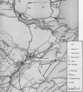
The Map shows an area of Scotland that can be classed as Munro Country (please note that the examples shown are parts of the map), it includes :-
Munro houses or sites, Church or churchyards, Battle or skirmish sites, Viewpoints, Towns and villages.
On the back of the map there is extensive information about the houses, parishes, churches, etc. and about the individuals and people who lived in the area (See below for an example of the text).
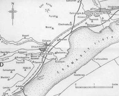
At the heart of the Munro country, in the parish of Kiltearn, is FOULIS, for at least 600 years the home of the chief of the clan, and in the words of its present owner 'the home of all Munros'. Robert de Munro, killed in defence of the earl of Ross about 1369, received various lands in the earldom including Easter Foulis and Strathskiach. The barony of Foulis is mentioned in a crown charter of 1553, and its 'tower and fortalice' in 1587; a document signed and sealed there in 1491 survives. Known in Gaelic verse as 'caisleal biorach, nead na h-iolair' (castle gaunt-peaked, the eagle's nest) in allusion to the chiefs heraldic emblem, it was burnt after the '45 rising, having held a government garrison and suffered at the hands of the Jacobites. Rebuilt over the next half-century, it has a tall four-storey tower dated 1754; in a courtyard with an enclosing battlemented wall pierced by three archways, the range of buildings includes a barrel-vaulted chamber with 16th-century 'key-hole gunports', uncovered during recent alterations.